

Frozen in Time: Capturing the Beauty of Baffin Island’s Disappearing Landscape
Only Antarctica and Greenland contribute more snowmelt to the rising sea level than the Canadian Arctic Archipelago.
 A small bit of the 6,000 km2 Penny Ice Cap sitting atop an unnamed peak on Baffin Island.
Venturing North
In August of 2019, I set out with a small team of fellow researcher-artists and intrepid explorers to the Penny Ice Cap on Baffin Island, a remnant of the last Ice Age, and a massive 6,000-square-kilometer block of snow and ice, in the Canadian territory of Nunavut. It lies north of mainland Canada and is a part of the remote Canadian Arctic Archipelago. To give you a little more geographical context, it’s directly west of Greenland and just north of the Arctic Circle.
Currently, the consensus among scientists and experts is that the Arctic is warming nearly twice as fast as the rest of the world due to the human-induced global climate emergency. Only Antarctica and Greenland contribute more snowmelt to the rising sea level than the Canadian Arctic Archipelago.
 The tongue of Tupermit Glacier in Akshayuk Pass. Auyuittuq National Park, Baffin Island, Canada.
Our team was there to work on a collaborative project involving visual artists and scientists to study specific environments that are experiencing tangible and dramatic ecological changes. What we hoped to achieve through our work is to share the beauty of our changing landscapes and provide people with a better understanding of the natural world. On this trip, we were documenting some of the area’s retreating glaciers. What follows is my fieldwork report.
 A terrifying beauty: fast-flowing ice melt on the Caribou Glacier on the Penny Ice Cap.
Trip Details
Pangnirtung is Intuit for, “The place of the Bull Caribou.” With a population of about 1,600, this small town is the frontier hamlet of Baffin Island’s Cumberland Peninsula. It was also our launching point. The geography around Pangnirtung is visually striking, varied, and extreme. This part of the world has a rich tradition of Inuit culture, particularly with stone-carving and tapestry weaving artists. And, thanks to the founding of Auyuittuq National Park in 1972, it is remarkably still wild.
Our team was made up of artists Ian van Coller, Bruce Crownover, Orion Willits, and myself, along with intrepid adventurers, Cam Dudiak and Doug Ingerly. We began our trek about 4 km south of Pangnirtung Fiord’s northern terminus, which we traveled to by outfitter Peter Kilabuk’s2 boat. Like most visitors do we hiked the Akshayuk Pass from south to north passing into the Arctic Circle around the 15th kilometer. Our goal was to hike as far as Summit Lake (approximately 35 km one way), to set up our base camp. From there we would take day trips up to the Penny Ice Cap, hiking up Turner and Caribou Glaciers along the way.
Luckily, everything on this research trip fell into place. We had stellar weather for six out of the eight days spent in the field, our camera gear operated perfectly, and our camping gear stood up the harsh northern conditions, keeping us warm, dry, and comfortable. On top of that, we suffered no major injuries, and our emergency beacon and insurance cards remained buried at the bottom of our bags. The dusk-light light from 11 P.M. to 3 A.M. provided nearly continuous daylight which enabled us to hike nearly any hour of the day (or night). Since the best lighting was around 4 A.M., so we would typically begin our day in the early hours of the morning.

Locals utilize atmospheric perspective (the stepped colors and values of the terrain) to help comprehend the scale. Look carefully: pictured above are five distinct layers or landscape curtains that aid in ascertaining distance. At the rear of the image is the Penny Ice Cap sitting on the flats of the massive Midnight Sun Peak, which is pictured ~20-30 miles in the distance.
Otherworldly Beauty
We all struggled to grasp this incredible landscape. Never have I been so immediately and completely affected by a love of place than what I encountered on Baffin Island. The sheer scale, remoteness, and austerity of this part of the world is, well, bananas.
Hiking through the long valley of Akshayuk Pass, which leads up to Summit Lake, is akin to simultaneously hiking a bigger Yosemite Valley and a more deserted Death Valley. Cliff faces the size of El Capitan are abound. Despite being nearly a mile away, it took our party several hours to traverse the base of the earth’s tallest cliff face, Thor Peak (~4100 continuous feet with an average overhang of 15 degrees).
In eight days we only saw six people — four of which were being picked up by our outfitter, Peter, as we were being dropped off on our first day. The other two folks we encountered were an amazingly fit pair of American rock climbers, Brian Knowles and Thomas Bukowski2.
 Former rock climber and intrepid adventurer Doug Ingerly catches his first glimpse of the ~4,100 ft overhanging face of Thor Peak (slightly right from center) during our trek to the Penny Ice Cap.
 Orion Willits crossing a fast-moving glacial stream. Far and away the most dangerous part of the trip was stream crossings like this one.
 Basecamp at Summit Lake. A view of Breidablik Peak (1650m) enveloped by Weeping Glacier and, to the right, the famous prow of Thor Peak (1675m). Tent-destroying wind gusts are not uncommon in the Akshayuk Pass on Baffin Island. My NEMO Kunai™ tent proved perfect for this environment.
 Our team traversing Caribou and Parade glaciers, two of the southernmost extensions of the Penny Ice Cap.
Merging Science and Art
Scientists who work in this area of the world most often rely on measurements of the ice cap’s various glacial tongues (e.g., Caribou, Turner, Coronation glaciers) and ice core analyses. Thanks to satellite imagery, scientists now know that the Coronation Glacier retreated 200 meters between 2004–2009. What’s more is that ice core analyses from the last six decades have shown higher melting rates, including on the surface, which suggests that the Arctic is reverting back to a warmer state that has not been seen in millennia.4
The sobering findings confirm that the glaciers of Penny Ice Cap are rapidly retreating. Just like Montana’s Glacier National Park, these glaciers will cease to exist one day in the future. Without them, they will also cease to transform the Auyuittuq National Park into a wholly different place than it is now.
Ultimately, the purpose of this trip was to raise awareness of global warming’s far-reaching impacts and to inspire action around climate change. Without meaningful art to convey the beauty of the Penny Ice Cap, and the reality of its eventual disappearance, it would be challenging to make people understand what is at stake.
However, I believe that places like the Penny Ice Cap need to be seen, artistically documented, and shared with the masses. Fundamentally, art is and will always be, culturally relevant. It has the power to address a complex topic like global warming. 5 But it can also be a symbol to communicate the importance of places like Baffin Island, whose staggering and wild beauty can never truly be described only with words.
 Dark snow and ice on Turner Glacier with views of the famous peaks of Mount
Asgard (far left) and Mount Loki (center right).
Why We Love Todd’s Work at NEMO:
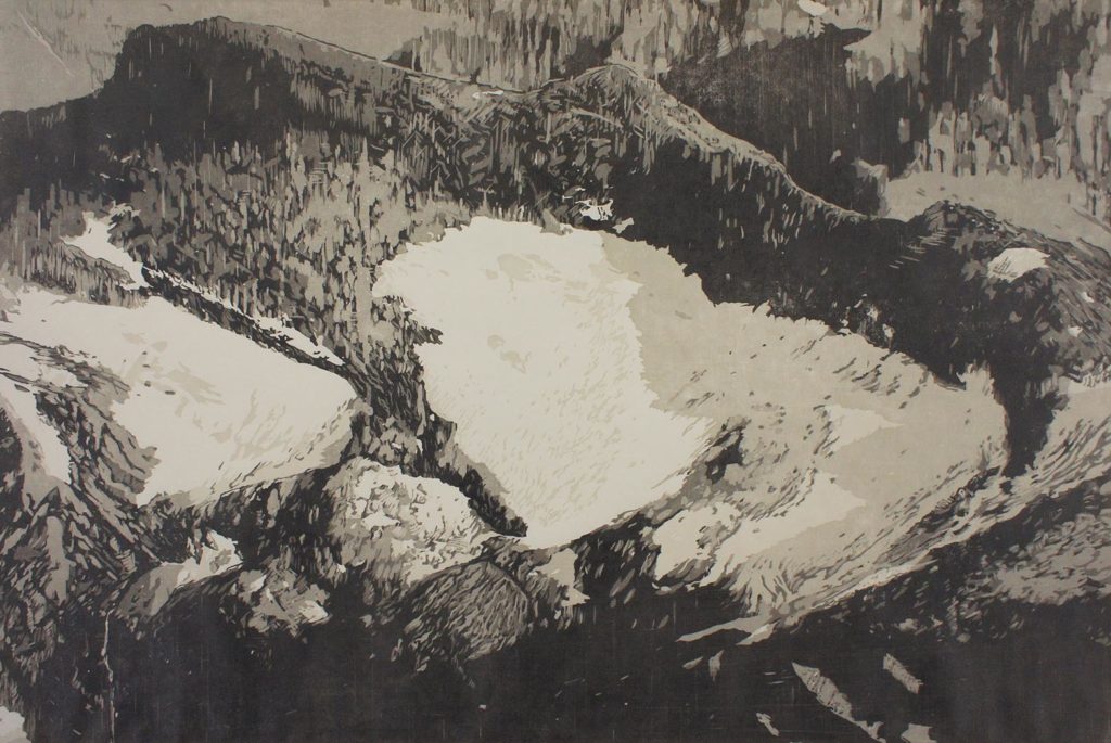
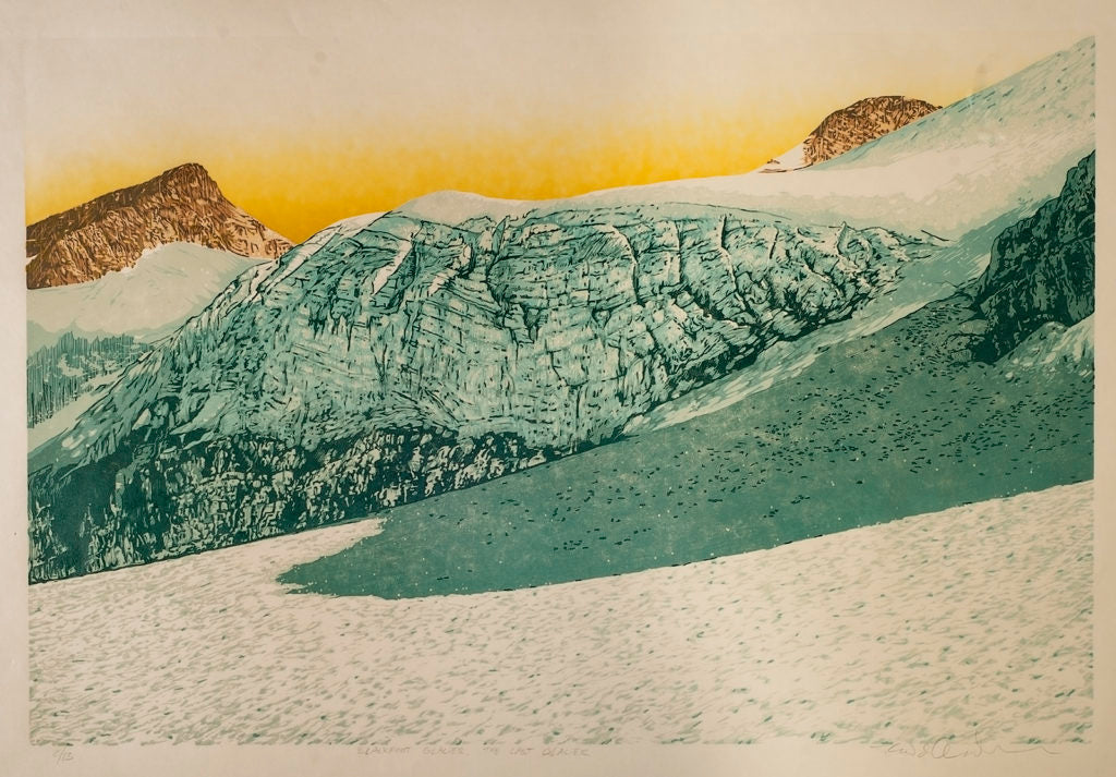
Todd’s woodcuttings are an awe-inspiring juxtaposition of real-life and imagination. They are at once dreamlike and detailed, with an ability to convey how it might feel to stand in a place so ancient and pristine. Pictured below are the woodcuttings from his trip to the Penny Ice Cap, featuring the Blackfoot Glacier and the Swiftcurrent Glacier. They also hang on the wall of our office here at NEMO and are something we get to admire every day. We hope that they also inspire you to notice the beauty of our natural world, from the epic to the ordinary, no matter what kind of adventure you may embark on.
About the Author, Todd Anderson:
Todd Anderson is an artist and professor who is part of an art collective called The Last Glacier. He conducts convergent research with scientists on the effects of global warming in various parts of the world. His 2019 trip to Baffin Island was the first part of a multi-year project that will culminate in the production of a hybrid art+science book about climate change in the Arctic. His artwork has been collected and exhibited widely, including by the US Library of Congress and the Metropolitan Museum of Art. A self-described Luddite and latecomer to social media, Anderson recently started an Instagram account—@ToddAndersonArtist. You can follow his work there or visit his team’s website, www.TheLastGlacier.com for more information about his work. To learn more about the climate crisis in the Arctic visit these sites: https://www.thearcticinstitute.org/projects/climate-change/ https://www.greenpeace.org/usa/arctic/issues/global-warming/ http://nsidc.org/soac/snow-cover.html#snowcover
Notes: 1 Greta Thunberg must here be acknowledged: “It’s 2019. Can we all now call it what it is: climate breakdown, climate crisis, climate emergency, ecological breakdown, ecological crisis and ecological emergency?” 2Peter Kilabuk: https://www.youtube.com/watch?v=S7CKPcr7BEM 3 See pictures of their trip on Instagram: neodude or BFK88 4 Zdanowicz, et al. “Summer melt rates on Penny Ice cap, Baffin Island, Past and recent trends and implication for regional climate.” Journal of Geophysical Research, Vol. 117 5 Bourriaud, N. Relational Aesthetics, 2002