

The (New Zealand) Mountains Are Calling, So I Must Go
Prologue
Mountains fascinate me. Skyscraping hunks of granite and schist have always drawn me in with a magnetism that is difficult to describe to those that have never experienced the aura of a mountainous panorama. For most, a mountainous landscape sparks thoughts of sore feet and a tired back. For those that see the opportunity that lies beyond the creature comforts of home, however... We’re rewarded with a dopamine-rich experience that only mountain adventurers can experience.

The Trek
New Zealand is the backpacking capital of the world. “Mecca” may even be an appropriate moniker. You probably know it from The Lord of the Rings series, where its rolling hills provided the ideal stand-in for the Shire and its mountainous landscape was a perfect fit for Mordor. I can happily say I spent extensive time in all of the landscapes the country has to offer and even climbed Mount Doom as a day trip prior to my solo trek.
Renowned for its stunning landscapes and pristine wilderness, New Zealand is a truly breathtaking country. With thousands of miles of trails crisscrossing the country, it is a haven for outdoor enthusiasts and adventurers. If one was so inclined, you could surf, hike 2,000 vertical meters, and visit a vineyard all in the same day. It's a magical place with outdoor adventures for anyone and everyone, so when the opportunity to visit arose, I quickly bought a ticket and started to formulate an itinerary.
I don’t like being alone. I have never camped alone. I almost never spend any significant time alone. I’m a twin, so by nature, solitude is not a concept I am familiar with.
This all changed with the rise of COVID, when suddenly everyone was thrust into the smallest social circle imaginable. Prior to this, I had never spent any time alone, nor had I entertained the thought that solitude could add value to my life.
All that being said, though, the thought of backpacking solo has always interested me. Enter: The Rees-Dart Trek.
In total, New Zealand is home to some 4,284 hiking trails, a staggering number for a country the geographic size of Colorado. Among these trails, the Rees-Dart Track is one of the most famous and challenging. This track is located in the Otago region of the South Island and traverses some of the most spectacular mountain scenery in the world. It has a variety of landscapes that seems impossible for one relatively small section of trail to contain.
In exactly 40 miles, “the Rees,” as the locals call it, has: 50+ river crossings, miles of trekking through open fields and pastures, old-growth beach forests, 3 glaciers, waterfalls, 2 bluffs, and a rather intense “saddle,” or mountain crossing. (Did I mention New Zealand has something for everyone?)
As I researched various treks close to where I was staying in Queenstown, this one quickly drew me in. The variability of the terrain was enticing and, with a relatively easy distance between Queenstown and the trailhead, it seemed logistically possible. What could go wrong? I thought as I booked a seemingly mundane van ride to the trailhead from the comforts of my stateside apartment.

Day 1 Overview
Journey to the Trail Head
Everyone is prepared for some level of danger when they go adventuring. Perhaps every scary movie you’ve ever seen runs through your brain before you drift off inside your tent. Any time a stick breaks somewhere in the distance, you're reduced to your middle school self, home alone for the first time. I myself was mentally prepared for all of these scenarios: monsters, Kiwi boogeymen, blisters, and ankle sprains, just to name a few.
I was not, however, prepared for the sheer terror that accompanied my death-defying van ride to the trailhead. Helmed by a 23-year-old (and questionably lucid) young Kiwi named Arthur, beginning this trek was no small feat. The country roads of New Zealand’s backcountry are haphazardly assembled through the rugged, winding wilderness. Originally built to service New Zealand's extensive cattle industry in a time before cars, these roadways have remained relatively untouched since the advent of modern transportation. Things like bridges, culverts, and signage are a luxury, not a necessity.

Arthur gave all eight passengers an extensive “briefing” that entailed nothing more than crossing each person's name off from a list and the proclamation that anyone who missed the ride home would be left to hitch. My trip officially began once Arthur was able to open the van door — “It’s broken on the outside mate,” he proclaimed in a thick Kiwi drawl. It wasn’t broken per say; the door handle had been completely sheared off, leaving a quarter-sized hole where the handle should have been. To say Arthur was not concerned was an understatement.
The van left from the heart of Queenstown at 7:30 a.m., making one stop at Glenorchy Township early in the morning. The first portion of my time with Arthur was uneventful, though we passengers quickly noticed his complete disregard for speed limits. As soon as the roads changed from pavement to gravel, things (including us) accelerated quickly.

Arthur’s driving went from slightly obnoxious, to impressive, to downright terrifying. The circa-1990s 4x4 handled the rugged terrain both very well and very poorly at the same time. Arthur pushed the small 4-cylinder van to its limits, shifting hard from second to third gear as we climbed sharp, winding inclines and ascended into the cattle field–laden foothills of Mount Aspring National Park. As our rapid climb continued, we came to the first river crossing of the journey.
Instead of slowing down and crossing the river carefully, Arthur chose the Kiwi route: While slowing a negligible amount on the decline into the river, he shifted hard from third down to second, slamming the van into the riverbed and bottoming out hard. Once in the river, Arthur floored the gas pedal, causing the van to accelerate rapidly out of river and then to bottom out again on the opposite side of the riverbank. All in all, the river we crossed was probably about 10 feet across and ankle deep, with banks rising a couple feet on either side. We bottomed out three times; once on entry, once in the middle of the river due to excessive speed, and once on exit, also due to excessive speed.
We crossed 13 rivers before reaching our destination. Upon arrival to the Muddy Creek trailhead, a British passenger who was sitting in front of me threw the van door open and projectile vomited into the parking lot.
I stumbled out of the van, carefully navigating the Brit’s breakfast and feeling drunk from motion sickness. The trek officially began.

No one wasted any time; all eight of us immediately began the slog along an almost 4-mile dirt road. As each individual’s pace took hold, we spaced out farther and farther apart. Suddenly the van, Queenstown, and home felt very far away as the only sounds that surrounded me were the crunch of my boots on the gravelly ground and the glacier runoff that surrounded me on both sides.
For those that have never been to this part of the world, the closest I can compare it to is parts of Montana. Rolling fields of lush, thigh-high golden grass make way for rushing torrents of turquoise water across the valley floor before succumbing to beach forests and rising quickly into massive shale mountainsides. The Rees River babbled along in the center of the valley and often served as my principal hiking path. My only company at this point were the several thousand cattle and sheep that called the valley floor home.
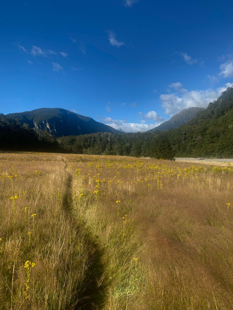
Other than apocalyptic depths of mud, the first day was relatively easy in backpacking terms — a veritable jaunt through the valley, the path eventually making its way to a gentle climb through a beech forest. The track followed the Rees River, and the views were stunning while the sound of the water flowing over the rocks soothed every step. After about eight hours of walking, I reached Muddy Creek and my first hut, a well-equipped structure with a kitchen, bunk beds, and even a coal burning-stove. I set up my bunk, cooked dinner, and went to bed early, eager for the next day's adventure.
Day 2 Overview
Mornings on a backpacking trip are as uneventful as they are intentional and productive. Devoid of news outlets or even coffee, my mornings were a race to pack, eat, and be on my way. The second day was far more challenging than the first, and my swift departure led to a tedious yet beautiful climb up out of the valley and through dense underbrush.
With the Rees River on my left, I hiked deeper into the mountains and gradually the valley floor rose to meet the bordering mountain tops. The trail began to follow a ridge and the elevation gain made for a noticeably more strenuous trek. Snow-capped mountains loomed in the distance and dozens of glacier streams created infinite river crossings. I stopped several times to catch my breath, take in the scenery, and snack on my preferred fuel of choice, Bumper Bars.

Eventually the trail climbed to the steepest portion of the 40-mile journey, the Rees Saddle. The saddle is a 1,400-meter, hand-over-hand sheer face of shale and gravel. For those unfamiliar with “saddles,” this mountain formation is a topographical low point that connects two parallel mountain valleys. Using my trekking poles as pseudo-ice axes, I slowly and surely made my way up the saddle. The climb was exhausting but rewarding: I could see for miles in every direction, and the scenery was breathtaking.

With the most difficult and technical portion of the entire journey behind me, I began the 2-day descent to my pickup point and trip back to Queenstown. After about six hours of walking along steep cliff walls and across valley-spanning bridges, I reached Dart Hut, which offered views of the Dart River Valley and towering mountains on either side. I spent the evening chatting with other hikers and enjoying the warmth of the fire. Unlike the other huts on this trip, this location permitted swimming and the glacier run-off was a welcome combatant to my sore muscles and tired back. After standing in a waist-deep pool for as long as I could handle, I returned to my bunk to read Into Thin Air within the cozy confines of my Disco 15.

Day 3 Overview
At this point, my journey had been pleasantly uneventful. I was happy, blister-free, and as well-fed/hydrated as any backpacker could hope for. Other than a mild sunburn and some sore muscles, my trip was going smoothly, and with the most difficult portion of the trek behind me, I was in good spirits. After making quick work of some oatmeal, I began my third leg — and what I thought would be the easiest portion of the trip.
Then came the rain.
Nothing quite prepares you for the first sting of rain that hits your face in the backcountry. It quickens your step and soaks you to the core. I had purchased a pack cover in Queenstown before starting this trip and was immediately grateful for the last-minute purchase. Donning my rain gear, I tramped forward on what would be the soggiest walk of my life.
The knee-high grass I mentioned previously went from a picturesque backdrop to a sock-soaking nuisance. Typically, you can keep your feet relatively dry when walking on dirt or gravel, but the grass trapped moisture in all around me and it was like walking on an ankle-deep sponge for eight miles. My boots soon reached the point where they squelched water with every step and doubled in weight, making each step a chore.
After about eight hours of walking, a roof top slowly came into view at the end of yet another gorgeous meadow. I had reached the third camp site of the trip, the Cascade Hut. This hut was in a very remote location, surrounded by mountains and glaciers that fed into a river which was now a full torrent. I spent the evening drying out next to the coal fireplace, finishing Into Thin Air, and pondering my next day’s journey.

As I lay in my bunk that night, my anxiety grew. Arthur’s warning about missing the trip back to Queenstown was fresh in my mind, as was the flight back to the North Island the following day that I would surely miss if I spent an unplanned extra day in the wilderness. My only assurance that I would catch the van at its 1 p.m. departure was an early start the next day.
Day 4 Overview
Sleep was hard to come by my last night on the trail. I tossed and turned for several hours before eventually drifting off, only to jerk awake at around 4:45 a.m. for a quick bathroom break. As soon as I got back into the bunkhouse, my mind drifted to thoughts of getting stranded in a random Kiwi parking lot. It was this paralyzing anxiety that made up my mind then and there: It was time to leave.
Under the visual cover of darkness and the audible cover of my snoring bunkmates, I readied myself for my departure. I quickly packed my Disco™ sleeping bag into its stuff sack, donned my freshest set of soiled clothing, lit my headlamp, and shuffled out the door into the still-spritzing darkness.
I’d never hiked at night before and my headlamp seemed like a flickering candle in the vastness of my surroundings. The cold, silence of the woods was only heightened by the blanket of mist that filled the air. Physically, this was the easiest day of the trek, but it was also the most challenging.
It started with a gentle descent through the Tolkien-esque beach forests that make up New Zealand’s backcountry. Miles slowly passed as I trudged my way through mild forest conditions. As the sun came up, the woods took on a soft, bluish-gray glow that allowed me to put away my headlamp.
This part of the trek, despite its panic-driven start, was relatively uneventful. Other than one instance of losing the trail and backtracking, I survived the cold and darkness unscathed, and was soon on the home stretch — a 2-mile trek that was added to the route due to a massive land slide several years back.
Meandering forest tramping suddenly shifted into a climb reaching high above the river, onto a path carved out of a towering cliff. The landslide had redefined this section of the valley, removing a huge portion of the mountainside in its path. This was the scariest section of the trek, with only a three-foot-wide path and small railing to separate me from a nearly 500-foot fall to the river below. The fear of missing the bus was suddenly the farthest thing from my mind.

Step by step, hand over hand, these cliffs eventually transformed back to the gentle forest paths that had made up much of my previous journey. Three hours later, I began to see hikers walking towards me with nothing more than a T-shirt and water bottle, a crucial sign that I was approaching my long-awaited terminus.
After turning a nondescript corner, I caught the glint of a car window’s reflection in the distance and a parking lot slowly came into view. My trek came to an end.

Conclusion
In a way, my trip ended as abruptly as it started. I wish I could say I returned from my trek a more enlightened, wise, or spiritually refreshed person, but the truth is that I was more focused on my souvenirs of waterlogged boots and sweaty clothes at the time.
It wasn’t until my flight home reached a cruising altitude that I had more mental clarity and felt a true sense of accomplishment. The hike was strenuous, sure, but this journey was also the longest time I’ve spent alone in my life, and to be honest, I had been more concerned about that challenge than the physical one.
The next time l fly across the world in search of mountains, though, I think I’ll opt to bring someone along to share them with.
Alex's Gear List:
- Hornet OSMO™ Ultralight Backpacking Tent - 1P
- Disco™ Men's 15 Degree Down Sleeping Bag
- Tensor™ Ultralight Sleeping Pad - Regular Wide
- Fillo™ Elite Ultralight Backpacking Pillow
The NEMO GO FAR (Get Outside For Adventure & Research) Program gears employees up and sends them out to spend time in interesting places in NEMO gear. We believe great design starts with real adventures, and are committed to making sure all NEMO employees get to experience it.
Alex is the Director of Digital Marketing at NEMO. When he's not in front of a laptop you can find him on a local mountain biking trail, trying a new killer recipe or endlessly waiting for the perfect powder day.